I love maps! I especially love old maps – they are like little time capsules and tell us a lot about the time in which they were created. This is a small part of a page from the Atlas of 1878. We can learn a lot about the history of the campus from this small image. Let’s take a walk on this campus.
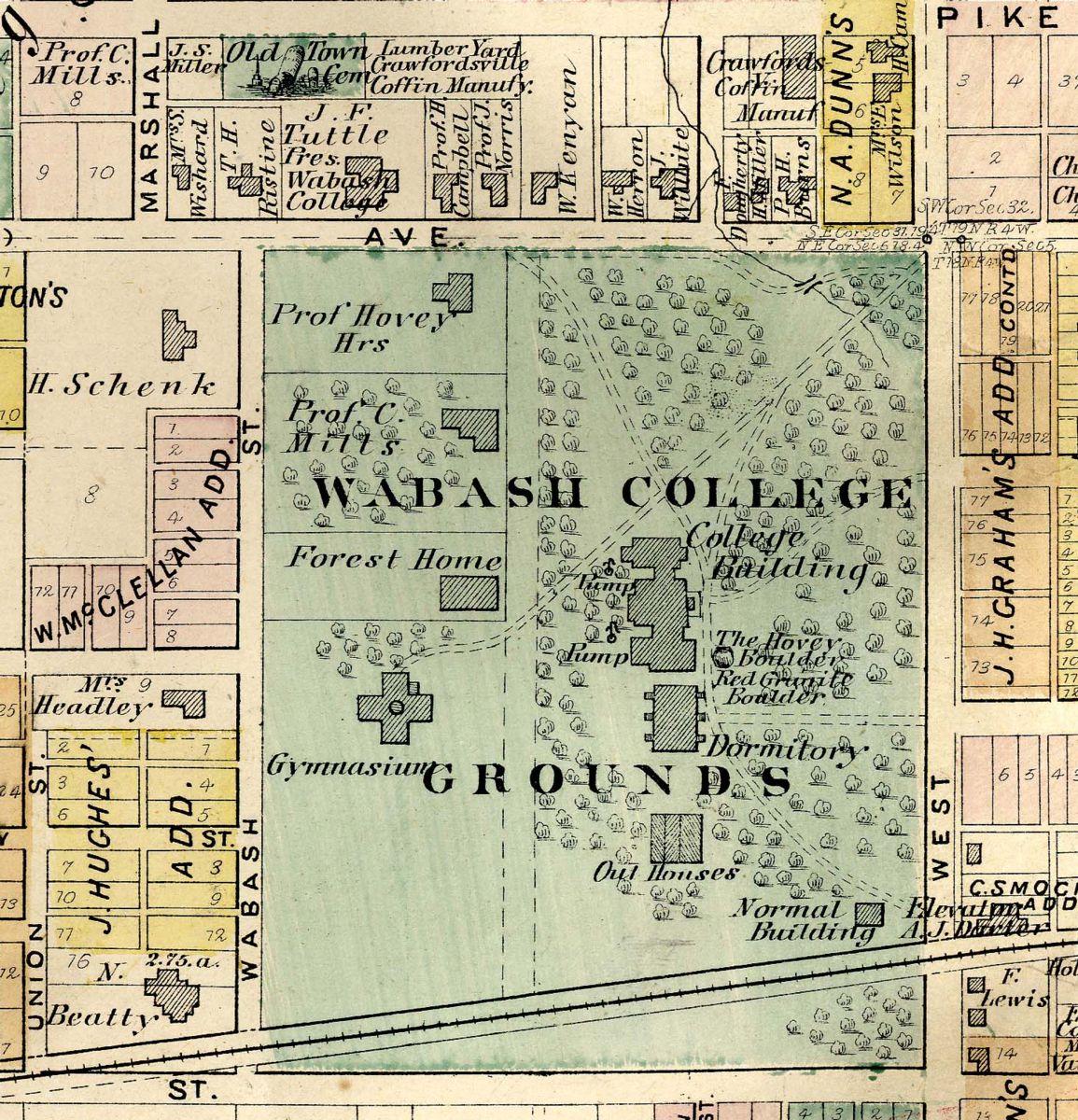
Starting in the center, the “College Building” is Center Hall, with its new library and chapel in the first and second floors of the north wing. Below that is the “Dormitory” this is the building known to most as South Hall, replaced by Baxter Hall. Just below that are the college outhouses, and the scene of many student pranks. The “Normal Building” which was later known as Kingery Hall, housed the teacher education department or Normal School. Destroyed in a Good Friday tornado a few years ago, that area is now the site of the Wabash Center for Teaching and Learning in Theology and Religion.
Jump briefly across West Street, which was yet to be named Grant and right where the railroad crosses there was a large grain elevator – where the Fine Arts Building is today.
Moving on around the map in clockwise fashion we see the “Gymnasium” which later became the Hovey Museum, then the Assembly Hall until finally the students just called it, “the Old Barn.” Too narrow for the new game of basketball, it was demolished in 1917 and the Armory built there. “The “Headley House” was the home of Atlas Minor Hadley, Principal of the Preparatory Department. This is the home that today we call the Kendall House, tucked in next to the Allen Center and the Class of 1950 Natatorium. “Forest Home” is, of course, Forest Hall which Caleb Mills bought and had moved to this campus. Forest has moved about a bit, but this location, about where the Sparks Center is today, was its first placement on this campus.
Next we see Caleb Mills’ house nestled among his beloved apple trees. Mills was passionate about his apples – it is said that he ended each day with a baked apple. Lucky was the student invited to his library for a cup of cider.
Just north of Mills was Edmund O. Hovey’s home on the hill above Wabash Avenue. In fact, this area was known as “College Hill” for many years. The homes on the north side of the street were those of faculty and friends of the college, including President Tuttle.
North of that area, we see the “Old Town Cemetery”. Actually mislabeled this was the Mills Cemetery, as it was owned by Caleb Mills. This was where our founders and the friends of Wabash were buried in the middle of the 1800′s. Now that area is occupied by the parking lot for Trippet Hall. In the years after this Atlas was drawn, this spot was developed for residential housing. The graves were very carefully opened and the contents quietly removed to Oak Hill Cemetery.
You may also note that “Prof. C. Mills” is the owner of three lots west of Marshall Street. Mills owned a bit of land in this west end area – given to him by the College in lieu of salary when money was tight. Mills named Marshall Street after his son who died too young and was buried in the cemetery.
It is so interesting to watch the campus change and grow.
I hope you enjoy this map as much as I did.